Winter isn’t ready to give up just yet.
On the heels of a massive windstorm and heavy snow in the Midwest and Great Lakes, an even more powerful storm is expected to arrive late Saturday and persist through Monday, pumping in yet another round of significant snow and high winds, setting the stage for dangerous blizzard conditions that will snarl travel across the regions.
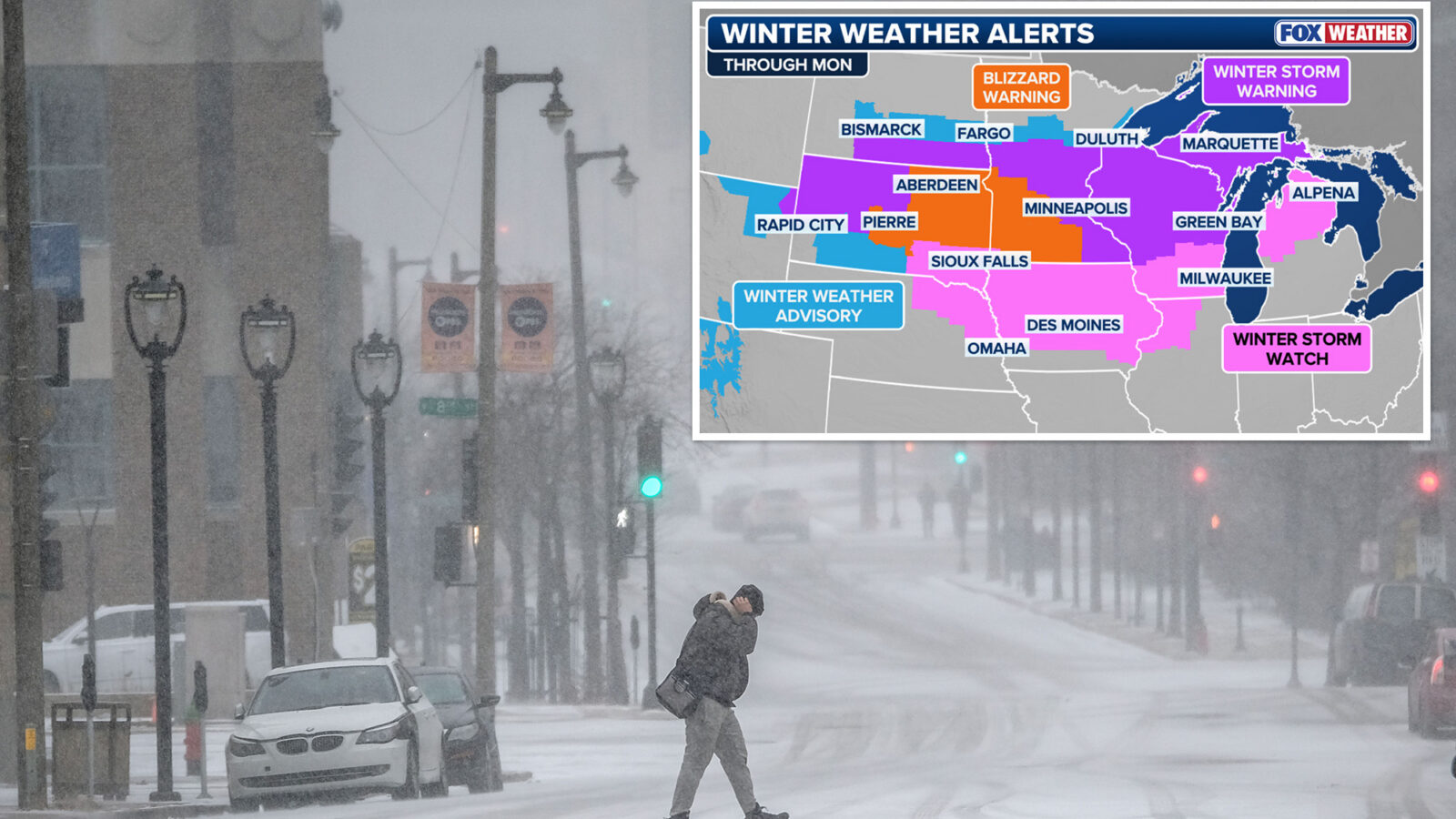
Millions across the Northern Tier are under Winter Weather Alerts, from Montana through Michigan.
Winter Storm Watches have been issued across much of the western Great Lakes, while areas in Minnesota, Wisconsin, South Dakota and Montana are already under Winter Storm Warnings.
Parts of South Dakota and western Minnesota are under Blizzard Warnings.
Ahead of the arrival of the threatening storms, flights have been proactively canceled in the Midwest in anticipation of the powerful storm that promises to cause travel troubles for regional travelers this weekend.
Due to significant forecasted snow and winds, Delta is processing cancellations at Midwest airports, including Delta’s Minneapolis-St. Paul hub, to ensure the safety of their customers, with more airlines likely to follow suit ahead of the dangerous storm.
Late Friday, a dip in the jet stream positioned across the Northwest pushed eastward into the Northern Rockies.
As this system moves into the Plains by Saturday, a surface low will develop and begin tracking into the Midwest and Great Lakes, packing wind gusts forecast to reach as high as 60–70 mph, providing the necessary ingredients for yet another strong storm in the North.
With high pressure remaining anchored over Canada, much cooler air will be ushered in behind this strengthening area of low pressure.
Morning Report delivers the latest news, videos, photos and more.
Please provide a valid email.
By clicking above you agree to the Terms of Use and Privacy Policy.
Please provide a valid email.
Never miss a story.
This colder air will allow precipitation across the Midwest to fall as snow and will likely expand into the Great Lakes region by Sunday.
The low will rapidly intensify as it moves into the Great Lakes.
The strong pressure gradient between the high to the north and the deepening area of low pressure will cause the winds to increase as well.
The heaviest snowfall is expected from eastern Minnesota through central Wisconsin into northern Michigan, where several feet of snow could fall by Monday evening.
This magnitude of snow may halt travel, severely disrupt cities, and cause power outages for thousands across the Great Lakes.
“We could see feet of snow. That is a lot of snow in areas that definitely do not need it. They’ve already gotten plenty of snow this winter,” FOX Weather Meteorologist Bayne Froney said.