Parts of western and upstate New York, downwind of Lake Erie and Ontario, are expected to see a lot more snow, prompting a State of Emergency in New York.
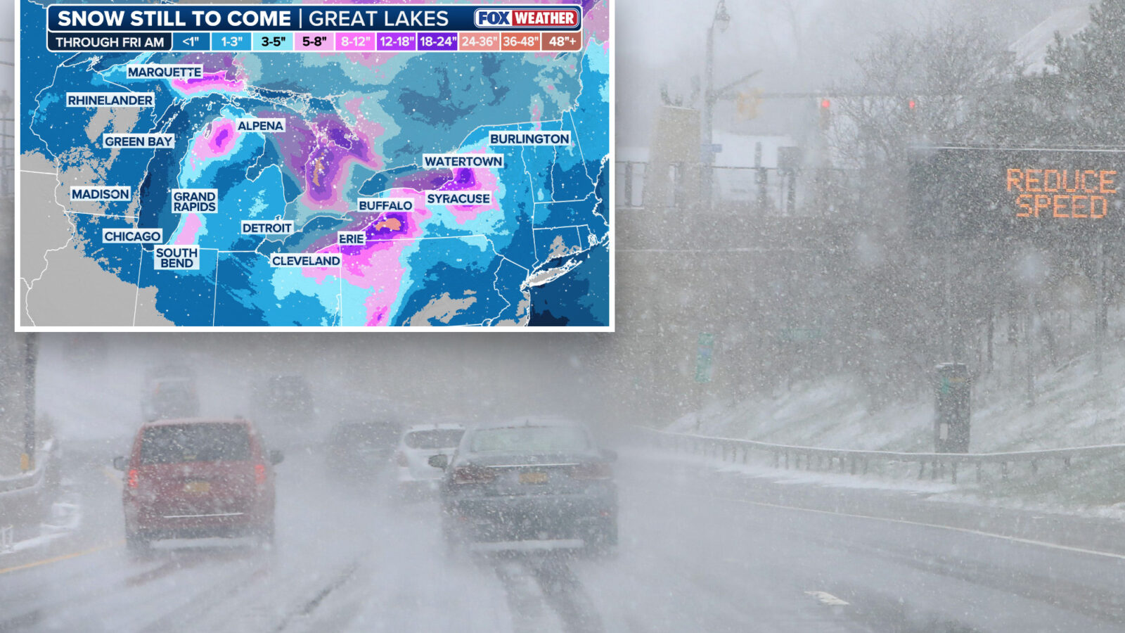
The eastern shores of Lake Michigan, parts of upstate New York and northwestern Pennsylvania could see 3 to 5 inches.
While downwind of lakes Erie and Ontario, including areas just south of Buffalo, NY, and southward into Erie, PA, Syracuse and the Tug Hill Plateau could see even higher amounts, with localized totals of 12 to 18 inches.
Overnight, Syracuse has already seen 10 inches of snow within just four hours and more is on the way.
The storm could cause low visibility and wind gusts up to 70 mph near the lake shores.
Governor Hochul is urging New Yorkers in affected areas to avoid travel and if possible, work from home, as treacherous roads and near whiteout conditions are expected.
We finally have a winter storm in downtown Buffalo! Conditions are not great but we can handle it and the roads are good. A travel advisory is in effect for Erie County. No unnecessary travel is recommended and if you must travel please have a winter survival kit in your car. pic.twitter.com/c6amr8uZNZ
As of yesterday, more than 7,500 utility workers engaged in damage assessment, response, repair and restoration efforts, stated Hochul.
Whiteout conditions are expected in several areas of Western and Central New York tomorrow, especially in the Syracuse-metro area.If you’re in an impacted area, please avoid all unnecessary travel, follow the direction of local authorities, and telecommute whenever possible. https://t.co/LwYP72f6XU
Coastal flooding is also possible in some areas as the strong winds push the water levels above normal.
Not only is New York under a State of Emergency, Winter Storm Warnings and Lake Effect Snow Warnings have also been issued for Syracuse, Buffalo and Erie, PA through Friday morning.
Morning Report delivers the latest news, videos, photos and more.
Please provide a valid email.
Morning Report delivers the latest news, videos, photos and more.
By clicking above you agree to the Terms of Use and Privacy Policy.
Never miss a story.
According to FOX Forecast Center, a dip in the jet stream settled just south of the Northern Tier, causing the northwest flow to continue to funnel air over the warmer water of the Great Lakes.
Several weaker disturbances embedded within the jet stream will track from west to east, supplying additional moisture and potentially enhancing snowfall across the Great Lakes and upstate New York through the end of the week.
NYS has expanded the State of Emergency due to ongoing lake effect snow & high winds. Hazardous travel and near whiteout conditions are expected for WNY, the Finger Lakes, CNY, and the North Country. Avoid travel and work from home if possible. More: https://t.co/lVNgX8GW88 pic.twitter.com/xOu1OhWKeN
On New Year’s Eve into early New Year’s Day, a weaker clipper is expected to move south from Canada through the Great Lakes, increasing the intensity of snowfall across western New York and portions of eastern Lake Erie.
This could even extend further into the Northeast, bringing lighter, decorative flakes to New York City and Boston.