Tens of millions of people across the US from the Plains to the Southeast are preparing for a potential multi-day severe weather outbreak this week, with forecasters warning of threats of large hail, damaging wind gusts and even some strong tornadoes.
Strong thunderstorms rolled across Oklahoma and Texas to end the weekend on Sunday, but the FOX Forecast Center said the more significant severe weather threat will begin late Monday and last through at least Wednesday.
The FOX Forecast Center said computer forecast models are highly confident that ingredients will come together to produce a widespread severe weather event.
This includes a strong area of low pressure developing in the Plains, which will then pull in warm and humid air from the Gulf.
That will provide the atmospheric energy needed for storms to develop and strengthen.
In addition, forecasters are concerned that strong winds aloft moving over the air mass will provide ample wind shear — the change in wind speed and direction with height — to allow for those storms to rotate.
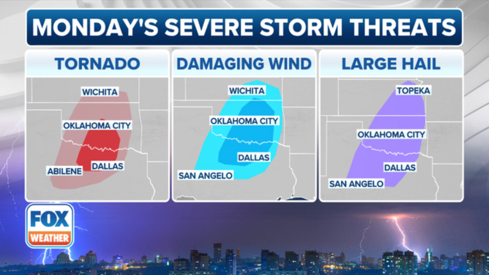
According to NOAA’s Storm Prediction Center (SPC), a rapidly developing line of thunderstorms could produce severe hail, damaging wind gusts and maybe a tornado or two across portions of the southern Plains by Monday night.
Forecasters say some supercell thunderstorms could develop before the storms combine into an organized line, and strong to severe thunderstorms could develop south-southeastward into and across the Interstate 35 corridor from south of the Wichita, Kansas, area, through Oklahoma City and into north Texas, including the Dallas-Fort Worth Metroplex.
What’s concerning to forecasters is that many of the storms are expected to develop as we head through the evening and overnight hours and into early Tuesday.
As we head into Tuesday, the severe weather threat will explode in population and coverage, with the SPC placing more than 41 million people from eastern portions of Texas and Oklahoma into western Georgia and the Florida Panhandle at risk of severe weather.
However, more than 3.5 million people in southern Arkansas, northern and central Louisiana and central and southern Mississippi have been placed in a level 3 out of 5 risk on the SPC’s 5-point severe thunderstorm risk scale.
Cities in the threat zone include Shreveport, Monroe and Bossier City in Louisiana, Pine Bluff in Arkansas and Jackson in Mississippi.
However, more than 3.5 million people in southern Arkansas, northern and central Louisiana and central and southern Mississippi have been placed in a level 3 out of 5 risk on the SPC’s 5-point severe thunderstorm risk scale.
“We want you to be prepared ahead of the storm system that is developing and intensifying as it’s working its way across the West,” FOX Weather meteorologist Kendall Smith said. “And by the time it arrives tomorrow (Tuesday), it’s going to have all of those severe weather ingredients in place that it needs for this to become a widespread, severe weather, and perhaps even a tornado outbreak.”
The FOX Forecast Center said that while damaging wind gusts appear to be the main threat from storms that develop, tornadoes could also be a big concern.
Forecasters say some tornadoes could even be strong, EF-2 or higher on the Enhanced Fujita Scale.
The severe weather threat will continue to barrel across the US by Wednesday, putting more than 67 million people along the East Coast from the Southeast to the mid-Atlantic at risk of some powerful storms.
The FOX Forecast Center said the line of storms on Wednesday may re-energize with the heating of the day, and that has forecasters concerned about the renewed severe weather risk.
The SPC placed an area from southeastern Georgia to southeastern Pennsylvania in a level 2 out of 5 threat, including cities like Baltimore, Washington, Virginia Beach and Norfolk in Virginia, Wilmington and Raleigh in North Carolina, Myrtle Beach in South Carolina and Savannah in Georgia.
Advertisement